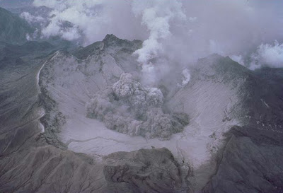
In August of 1990, a month ater the July 16 earthquake, reports were made to PHIVOLCS by Pinatubo Aetas of roars, ground cracking and a higher steaming activity of the thermal area¹ of Pinatubo. The possibility of an incoming eruption was brushed off by the dispatched response team. They attributed all of the aforementioned activities to landslides caused by several aftershocks and also by the monsoon rains during that time.
Ancient Pnatubo - Credit : C.G. Newhall, U.S. Geological Survey
Steam clouds and ash emissions appeared April of the following year, Seismic activites indicated movements underneath the crater and the possibility of a volcanic eruption. Evacuation of several Aeta tribes living on the slope of the mountain started on June 8th. The US Air Force initiated a massive evacuation effort to remove personnel and ther families living in Clark Air Base out of harm's way during and after the eruption of Mount Pinatubo. Most of them were relocated to Guam, Okinawa and Hawaii.
Pinatubo eruption
On the morning of 12th of June 1991, a 20km-high ash cloud was created from a powerful explosion from Pinatubo. This cloud moved to a NW direction and covered the sky. Several explosions were reported during the day. Abundant ashfalls and ejecta reached Olongapo and Angeles as well as villages within 20 km from the crater. As the dome became more dangerous, thousands of people living around the volcano started moving out of the hazardous areas, while ashfalls had already blanketed hundreds of square kilometers. Another explosion happened the day after and the ash reached as far as Zambales, Pampanga and Tarlac. As fate would have it, a typhoon (international name Yunya, locally called Diding) struck the country on June 15th. Pyroclastic flows poured from the summit reaching as far as 16km from it. Typhoon rains mixed ash deposits caused fatal lahar flows.
Pinatubo 1991 eruption - Credit : T.J. Casadevall, U.S. Geological Survey
Manila was affected, too. On June 18, the city was darkened during daytime and covered by almost half a centimeter of ash.
At the second half of June, the ash clouds has crossed the South China Sea and reached Vietnam and Cambodia. They continued to circulate westward and was reported to have reached Hawaii by July 1991.
An estimated 900 people lost their lives as a consequence of the explosion. Some were from the Pinatubo Aeta tribe as a result of their refusal to leave their houses. The rest of the fatalities were from the cities mostly from collapsed roofs, houses and buildings due to the weight of the ash.
Source:


